Rajshahi Division
This article has been extracted from THE IMPERIAL GAZETTEER OF INDIA , 1908. OXFORD, AT THE CLARENDON PRESS. |
Note: National, provincial and district boundaries have changed considerably since 1908. Typically, old states, ‘divisions’ and districts have been broken into smaller units, and many tahsils upgraded to districts. Some units have since been renamed. Therefore, this article is being posted mainly for its historical value.
Rajshahi Division
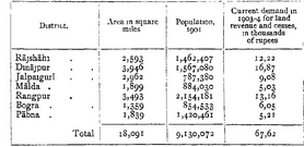
Division or Commissionership of Eastern Bengal and Assam, extending from the Ganges to the Himalayas and lying between 23 49' and 27 o' N. and 87 46' and 89 53' E. It is bounded on the east by Assam and the Dacca Division, and on the west by the sub-province of Bihar. The Division was formerly part of Bengal and then included the District of Darjeelmg ; but in 1905 it was transferred to Eastern Bengal and Assam with the addition of Malda District, while Darjeelmg was transferred to the Bhagalpur Division of Bengal. The head-quarters of the Commissioner are at JALPAIGURI. The Division includes seven Districts with area, popu- lation, and revenue as shown below :
The population increased from 7,955,087 m 1872 to 8,280,893 i n 1881, and to 8,609,007 in 1891. The density of population is 505 persons per square mile, as compared with 474 for the whole of Bengal. Of the total, 62-4 per cent, are Muhammadans and 36-3 per cent. Hindus. The small lemamder consists of Ammists (103,633), Buddhists (6,352), and Christians (4,448, including 3,494 natives). About half the Hindus are the aboriginal Rajbansib and Kochs, and the gieat majority of the local Muhammadans are the descendants of converts from these tribes.
The northern part of the Division consists of a strip of submontane country, in Jalpaiguri, running along the foot of the Himalayas. This tract contains large and valuable forests, and the conditions are also very favourable to the growth of tea } the area under this crop in Jalpaiguri was 121 square miles m 1903, and the out-turn in that year amounted to nearly 37 million pounds, The remainder of the Division forms part of the great Gangetic plain. The surface con- sists of recent alluvium, except in portions of Malda, Rajshahi, Dmaj- pur, and Bogra, which belong to an older and more elevated alluvial formation known as the BARIND. More than half of the tobacco crop of Bengal is produced in Jalpaiguri and Rangpur, and jute is exten- sively cultivated m the south-east of the Division, while the rice of Dinajpur is well-known. The Division contains 18 towns and 3 I j33 villages, The laigebt towns are SIRAJGANJ (population, 23,114) and
RAMPUR BOALIA (21,589). The chief place of commercial impor- tance is the jute mart of Sirajganj. A considerable amount of trade also passes through SARA, where the northern section of the Eastern Bengal State Railway meets the Padma, or main stream of the Ganges ; SAIDPUR is the head-quarters of this section. GAUR and PANDUA were capitals of the early Muhammadan rulers of Bengal and contain ruins of great interest \ DEVIKOT, GHORAGHAT, MAHASTHAN, and SHERPUR also possessed some importance under Muhammadan rule, and many traditions of earlier times are associated with the ruins at these places ; but with these exceptions the Division contains few places of historical interest.
